Geophysical Techniquessurface and borehole geophysics
Geophysical Applications, Inc. has expertise in a wide variety of geophysical methods that help our clients more thoroughly investigate the subsurface. Our senior personnel have performed geophysical surveys for more than 30 years each, and can design a survey that is cost-effective and accurate.
- Ground Penetrating Radar (GPR)
- Seismic Refraction
- Magnetometry
- Electromagnetic Terrain Conductivity (EM)
- Very Low Frequency (VLF) Profiling – Electrical Resistivity Imaging, Soundings, and Profiling
- Borehole Geophysical and Video Logging
- Crosshole Seismic Testing
- Seismic Tomography
- Microgravity Surveys
Following are brief descriptions of geophysical survey techniques, selected applications, and advantages provided by Geophysical Applications, Inc.
Ground Penetrating Radar (GPR)
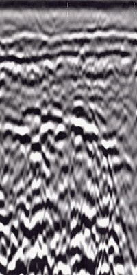
– The GPR method uses high-frequency electromagnetic waves to provide detailed subsurface cross sections.
- microwave energy reflected back to the surface from different materials produces various electrical results
- Metal objects produce the strongest results, determining location, depth and size
- GPR can also identify excavations, for example where tanks were removed, and can delineate the boundaries of landfills and buried lagoons
- higher-frequency antennas (typically 900 or 1,500 MHz) are utilized for surveys on concrete slabs, to locate rebar, electrical conduits, or other pipes prior to core drilling or saw cutting.
The staff of Geophysical Applications is skilled in digital signal-processing techniques that enhance GPR data interpretations. Signal processing can reduce background noise and identify weaker reflections (such as from fiberglass USTs, or subtle stratigraphic variations) that would remain undetected using analog GPR instrumentation.
Seismic Refraction
– The seismic refraction utilizes acoustic waves generated by an impact or small explosive source to measure depths to bedrock or overburden layers of sedimentary rock and to infer bedrock faults or fracture zones.
- Seismic response are plotted through distance along the geophone array to identify individual layers, and to compute layer thicknesses and seismic velocities.
- Specific geologic conditions, such as bedrock fractures or valleys, may be interpreted directly from these time-distance plots or by using several seismic modeling techniques.
- Low-velocity zones and thin strata may be undetected using older interpretive methods, such as the crossover distance technique.
Geophysical Applications can use SeisOpt2D velocity modeling to identify these “hidden layer” conditions. SeisOpt2D also provides a means of quantitatively evaluating lateral seismic velocity variations that can represent lithologic contacts or fracture zones. Geophysical Application’s software can also perform forward modeling to design geophone and shotpoint spacings needed to achieve specific survey objectives.
Magnetometry
– Magnetometry can detect buried ferrous objects such as underground tanks and drums, or geologic structures such as igneous dikes, that cause local disturbances in the earth’s magnetic field.
- The shape of these magnetic “anomalies” indicates the location and approximate burial depth of the anomaly sources
- Can be hampered by above-ground metal objects and overhead power lines which interfere with data collection
Advanced instrumentation, such as continuously-recording “walking” magnetometers, enable Geophysical Applications to conduct more thorough magnetic surveys than can be achieved using conventional instrumentation.
Electromagnetic Terrain Conductivity (EM)
– The EM method measures the conductivity of earth materials, buried objects, and backfill utilizing electromagnetic induction.
Comparing in-phase and quadrature EM data, or EM and magnetic contour maps, can benefit a project by differentiating ferrous and non-ferrous sources of elevated conductivity (such as drums versus landfill leachate).
Electrical Resistivity Imaging, Soundings, and Profiling – Electrical resistivity methods can measure depths to groundwater and bedrock, and locate clay layers, sand and gravel deposits, and leachate plumes from lagoons or landfills.
Geophysical Applications utilizes digital resistivity instrumentation and the linear filter modeling technique to obtain accurate layer thickness interpretations during resistivity sounding surveys. Automated dipole-dipole profiling surveys are conducted using an ABEM resistivity system or Advanced Geosciences Sting resistivity meter and Swift electrode array, with inversion software to generate contoured resistivity cross sections.
Very Low Frequency (VLF) Profiling
– The VLF method utilizes 15 to 30 kHz radio signals generated by military transmitters around the world to locate water-bearing bedrock fractures or zones of conductive mineralization at depths up to 100 feet.
Geophysical Applications utilizes digital VLF instrumentation to measure the in-phase and quadrature-phase components of the secondary EM field from which the approximate depth and dip angle of a conductive fracture may be determined.
Borehole Geophysical and Video Logging
– Enables more detailed characterization of lithologic and groundwater flow conditions than cuttings, split-spoon samples, or core samples alone. An advantage of borehole techniques is that they can describe subsurface conditions in greater detail than surface-based methods.
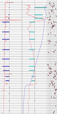
Geophysical Applications, Inc. owns acoustic and optical televiewer probes, to allow measuring fracture and bedding-plane dip angles and down-dip compass azimuths. Our Advanced Logic Technologies (ALT) model ABI40 and FAC40 acoustic televiewers can detect fractures with aperture greater than 0.1mm. Both our FAC40 and optical OBI40 televiewers contain three-axis magnetometers and two or three inclinometers, to maintain the probes’ orientation with respect to magnetic north and verticality.
Geophysical Applications utilizes digital geophysical logging instrumentation to enable post-survey playback of logs at varying scales. This is particularly important in fracture identification, where subtle changes in fluid temperature or conductivity may represent a zone of significant groundwater flow.
Crosshole Seismic Testing
– Crosshole seismic measurements determine dynamic elastic moduli including shear modulus, Young’s modulus, and Poisson’s ratio.
Geophysical Applications conducts crosshole seismic surveys in accordance with ASTM standard D-4428 to assure reliable velocity and moduli computations. We own a GeoStuff three-component geophone set with a built-in digital compass and servomotor, to allow orienting the longitudinal geophone element along any desired azimuth.
Seismic Tomography
– Seismic tomography uses an array of borehole (and possibly surface) geophones or hydrophones to characterize materials outside a borehole. Multiple seismic source locations, both within the boreholes and along the ground surface, create intersecting seismic raypaths.
Microgravity Surveys
– The microgravity method measures very small variations in the earth’s gravity field. Depths to bedrock, approximate fill thickness, and locations of faults, buried river channels, fissures, and solution cavities may be determined by measuring the earth’s gravity field at numerous stations along a traverse, and correcting the gravity data for elevation, tidal effects, topography, latitude, and instrument drift.


